Field Trip Three
Charlemont, MA
September 26, 2013
Geologic Context:
In this field trip, we saw outcrops that were formed mostly in the continental slope/rise when the Laurentian margin was transitioning and had transitioned into a passive margin. These rocks formed deeper than the rocks from the continental shelf that we saw in the second field trip. The Moretown, the last outcrop on this field trip, will be discussed further in the next post but appears to be a microcontinent of Gondwana, or Africa.
Mesoproterozoic:
1.1 Ga, Grenville Orogeny (Basement rocks)
- See Week 1 Field Trip, Continental Shelf
Neoproterozoic to Early Cambrian:
700 Ma: Post-Grenville rifting
Continental Rift to Drift Transition
Breakup of Rodinia
 |
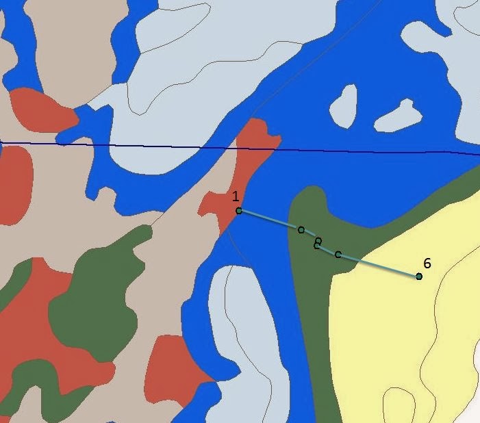
| 3.i: Lithotectonic map showing the location of the week 3 field trip in Charlemont, MA |
Description from USGS MA geologic map:
-Hoosac Formation
-Green to gray-green phyllite
-Interbedded chloritoid or albite-rich schist
-Some quartzite
-In places, rich in garnet or kyanite
From the geologist's notebook- field notes
-Alternates between darker and lighter layers
-Darker layers are carbon-rich
-Fine bedding, very distinct
-Some folds
-Medium-grained matrix
-Muscovite, quartz, plagioclase feldspar (albite), graphite-rich layers
-Weathering around quartz gives quartz veins and clasts an occasional reddish/rusty hue
-Helictic inclusion trail, crenulation cleavage
-Strike: 345
-Dip: 25
What causes a helictic inclusion trail?
A helictic inclusion trail is a trail of inclusions, in this case a mineral found inside another mineral, that form a shape similar to the letter "S." They are caused by deformation during metamorphism as one mineral begins to alter into the other. In the Hoosac Schist, we saw albitic plagioclase with graphitic cores.
How are quartz veins created?
Extremely hot mineral-rich fluids that are left over from magmatic processes can migrate quite far before being deposited and solidifying. Sometimes, the fluid moves along fractures or bedding planes, where it cools, forming vein deposits like the quartz veins seen in this schist and other formations on our field trips.
 |
| Figure 3.1: Piece of Hoosac Schist from Stop 1. A quartz vein is outlined in purple, indicating that minerals flowed through a weak fracture zone in the schist |
The Hoosac Schist was deposited as slope-rise sediments off the coast of Laurentia. An original deformation likely caused the quartz veins to form, caused the NW dip of this outcrop, and created the foliated fabric. A second deformation, likely during the Acadian Orogeny, folded the foliations that had already been caused by the Taconic Orogeny.
Stop 2: Rowe Schist
Description from USGS MA geologic map:
-Light green to bluish-gray schist
-Thin, granular quartz lenses and lamellae
-Kyanie and staurolite present at higher grades
-Fine-grained matrix
-Shiny and silver, highly aluminous
-Similar to Hoosac Schist in composition but contains paragonite instead of biotite (sodium endmember) and chloritoid but no albite
-Chloritoid found as specks
-Paragonite present with muscovite
-Green tinge caused by chlorite
-Strike: 1
-Dip: 82
 |
| Figure 3.2, Rowe Schist from Stop 2, late Ordovician. Note the silver luster, an indication of the high mica and aluminum content of the Rowe at Outcrop 2 |
Interpretation:
The Rowe Schist was originally thought to be a product of deep ocean sediments, likely sediments from the abyssal plain of the Iapetus Ocean. The Rowe was interpreted in this way because of the "black cruddy" qualities of the schist, indicating that it is high in carbon. It also has a large amount of graphite, which is often found in anoxic environments. It now seems likely that the Rowe Schist was formed closer to the continent of Laurentia than previously thought, probably on the slope/rise instead of the deep ocean. An alternate explanation for the high graphite presence is that graphite can sometimes precipitate into zones of weakness like a thrust fault. If a thrust fault were present in the Rowe, graphite could have precipitated through the fault and caused the graphite-rich rocks we see today. The paragonite and chloritoid evident in this outcrop are a result of the high aluminum content of the Rowe, which may be a further indication of its proximity to Laurentia since continental environments tend to be aluminum rich.
Stop 3: Rowe Schist
From the geologist's notebook- field notes
-Fine-grained matrix
-Less shiny than the previous outcrop (though still lustrous), darker grey
-Increase in quartz
-Ankerite crystals present
-Clear boudinaged quartz veins
-Strike: 345
-Dip: 66
-Lineation trend: 130
-Plunge: 48
For a basic interpretation of the Rowe Schist, see Stop 3. In this outcrop specifically, we saw the presence of ankerite crystals and an increase in quartz. Both ankerite and quartz are predominantly continental minerals. The increase of these minerals in this outcrop could indicate closer proximity to Laurentia or a change in depositional energy that carried continental materials farther along the continental slope.
Stop 4: Rowe Schist
From the geologist's notebook- field notes
-"Black and cruddy" schist
-Black and extremely crumbly, highly carbonaceous
-Clear contact between "cruddy black schist" and shiny, silver schist: both Rowe, just different varieties
-Very quartz-rich, easiest to see parallel to cleavage (parting cleavage)
-Graphite-rich
-Quartz, ankerite, graphite, muscovite, biotite, pyrite
 |
| Figure 3.5: Rowe Schist at Stop 4. The orange line represents the contact between the dark "cruddy" Rowe Schist and the lighter, silver Rowe schist |
 |
| Figure 3.6: Closer view of Rowe Schist at Stop 4. Note the darker, carbon-heavy Rowe Schist with abundant surface lichen |
Interpretation:
In this outcrop of the Rowe, we see a new variety of the schist: "black and cruddy." Although black and crumbly sediments like these can form in anoxic environments with a large amount of biogenic material, they can also form when sedimentation rates are fast enough to prevent oxidization (sediment is buried before oxygen can reach it). This latter interpretation is consistent with the view that the Rowe was likely closer to the continental shelf than previously thought.
Stop 5: Reed Brook Nature Conservancy
From the geologist's notebook- field notes
-Fine-grained ultramafic rock
-Black, fine-grained
-Contains green crystals (could be olivine but is likely an alteration product)
-Heavy surface lichen
-Surface weathering evident
 |
| Figure 3.7: Schist from Stop 5 shown on the right: it is fine-grained and uniform in texture and color. On the left is a piece of foliated gneiss with a higher felsic component. |
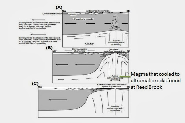
These are ultramafic rocks within the Rowe Formation. They were once thought to be ophiolite packages. ophiolite packages occur at suture zones after an orogeny. They are pieces of the earth's mantle that are uplifted into continental crust after a collision event. However, if the Rowe is not, in fact, a deep sea formation, then the ultramafics seen here are unlikely to be ophiolites. Instead, they could be a result of upwelling of the asthenosphere that occurred when the rifting phase transitioned to the drift phase. This view is presented by Withjack et al. in their 1998 paper. As the Moretown was thrust over the Rowe, the ultramafics may have been brought from the crust to the surface.
Stop 6: Moretown Formation
Mid-Ordovician
From the geologist's notebook- field notes
-Light and dark layers, alternating
-Gneissic fabric
-Light layers are a quartz-rich
-Also layers of a quartz-rich phyllitic schist, fine-grained
-Folded quartz veins (Figure 3.9)
-Light layers contain visible bedding
-Darker layers are biotite-rich
-Pyrite and calcopyrite within a "hodge podge" of rock types (Figure 3.8)
 |
| Figure 3.8: Pyrite inclusion within Moretown Formation seen at Stop 6 |
 |
| 3.9: Moretown Formation, Stop 6. A large quartz vein is outlined in purple. The hand in the picture is completely covering the pyrite inclusion, providing a scale for the size of this inclusion. |
Interpretation:
The Moretown Formation was likely part of the Shelburne Falls Arc Complex. The volcanic arc formed on a microcontinent, Moretown, which was once a part of Gondwana but rifted off. The zircons present in the Moretown show an affinity to Gondwana, supporting this claim. Moretown was thrust over the Rowe Schist when it collided with Laurentia during the Taconic Orogeny. Moretown will be discussed in more detail in the next post.
This map shows the locations of these sites on a Google map!
Conclusions
When we left off of our discussion of rift sediments, we had covered shelf deposits and slope/rise deposits. The next logical progression seems to be rocks formed in even deeper water- the abyssal plane of the ocean. However, this field trip showed us that sediments like the Rowe Schist are not explained quite so simply.In the past, the Hoosac and Rowe Schists were thought to be slope/rise sediments, with the "black, cruddy" Rowe Schist marking a transition to deeper ocean deposition in the form of an accretionary wedge of the Shelburne Falls Arc (discussed in more detail next week). However, there are alternative explanations for the formation of the Rowe that do not require its formation in the deep ocean and are actually more consistent with our observations, such as zircons that show an affinity for Laurentia. It is likely that the Rowe was actually formed solely on the slope/rise (and not in the deep ocean). The high carbon content of the black, cruddy Rowe, which is often interpreted as a product of anoxia in the deep ocean, could also be interpreted as a product of a sudden increase in sedimentation rates along the slope/rise, presenting oxygen from reaching buried sediments. Graphite is often formed in anoxic environments, but it is also possible that it percolated through faults, or zones of weakness, within the Rowe.
One possible explanation for the formation of the ultramafics from Reed Brook is that they are a product of extension, which caused magma from the mantle to upwell. The diagram below shows how upwelling of the asthenosphere can bring mantle material to the surface.
 |
| 3.10: Diagram adapted from Withjack et al. (1998) shows how upwelling of the asthenosphere could occurr due to extensional rifting. |
The Moretown Formation will be analyzed in more detail next week. However, in order to have a basic understanding of how it fits in to the picture, it is important to note that the Moretown was previously interpreted as a fore-arc basin of the Shelburne Falls Volcanic Arc Complex. However, this is likely not the case... an argument that will be presented in regard to next week's field trip: Week 4: The Shelburne Falls Arc Complex.
Withjack, M.O., Schlische, R.W., and Olsen, P.E., 1998, Diachronous rifting, drifting, and inversion on the passive margin of central eastern North America: An analog for other passive margins: AAPG Bulletin
Personal communications with Paul Karabinos and Eloise Andry


No comments:
Post a Comment