Tuesday, November 12, 2013

Week 1: Continental Shelf Rift to Drift Transition

Field Trip One
Bennington, VT
September 12, 2013


Geologic Context:


In this field trip, we look at rocks that make up the Laurentian Basement (Mesoproterozoic) and the Laurentian passive margin, representing the continental rift to drift transition.


Mesoproterozoic:
1.1 Ga, Grenville Orogeny (Basement rocks)
Neoproterozoic to Early Cambrian:
 700 Ma: Post-Grenville rifting
Continental Rift to Drift Transition
Breakup of Rodinia

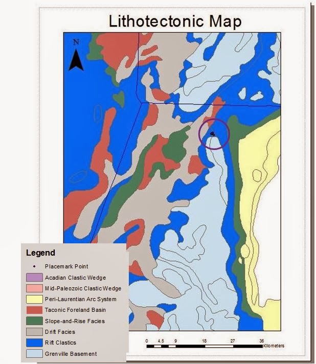
1.i: Lithotectonic map showing the general location of field trip one in Bennington, VT
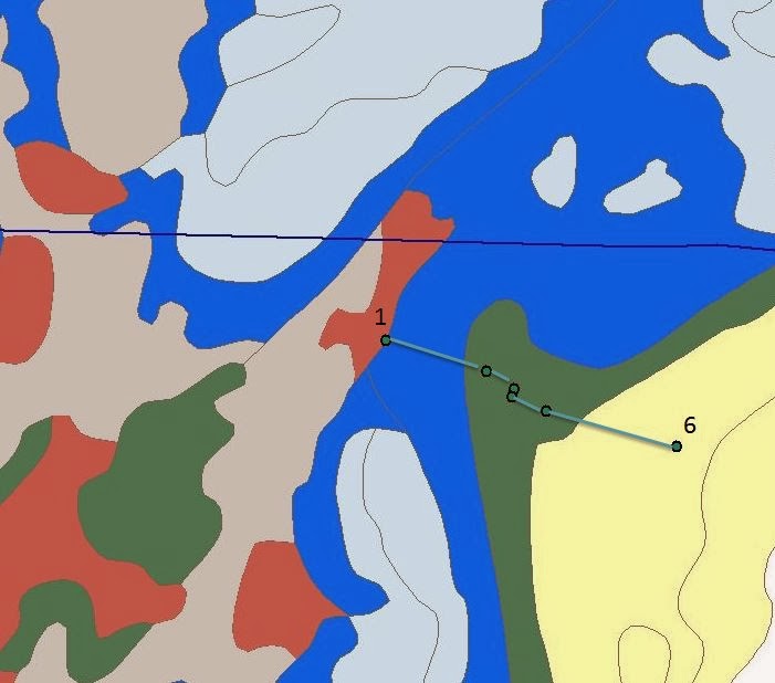
1.ii: Zoomed in lithotectonic map showing the field trip stops, starting on the right (Laurentian basement), and moving left (drift facies). 


Stop 1:  Mount Holly Complex
Mid-Proterozoic 

Formation description from USGS VT geologic map:
-Fine to medium grained biotite gneiss
-In parts, muscovite and chloritoid present
-Abundant hornblende and amphibolite
-Minor beds of mica schist, quartzite, and calc-silicate granulite
-Pegmatites present along with various meta-granites and metatonalites
-Some characteristics of a calc-alkaline volcanic-plutonic suite

From the geologist's notebook- field notes
-Gneiss, alternating light and dark granite bands
-Light stripes are basement pegmatites, look similar to granite
-Dark stripes are mafic-rich
-Contains minerals: biotite, quartz, feldspars, hornblende

-Strike: 220 degrees (Southwest)
-Dip: 66 degrees (Northwest)


What is gneiss?

Gneiss is a common fabric seen in metamorphic rocks. It has alternating bands of light and dark-colored rocks and is strongly foliated. It is caused by high grade regional metamorphism. When we see gneiss in the field, we know that the rocks have undergone a deformation event that involved high temperatures or pressures. 

What exactly is a "fold," and what causes them?

Folds are wave-like patterns formed when otherwise horizontal layers of sedimentary or igneous rocks are deformed at a convergent margin. They result from compression; as the crust is pushed inward, it shortens and thickens. The sides of a fold are called "limbs," and each layer is called a "hinge." The "axial plane" describes the imaginary line that could divide the fold as symmetrically as possible. 

Anticline: Usually created by upfolding/arching, the oldest strata are found in the center
Syncline: Downfolds/troughs, the younges strata are found in the center

1.1: Gneiss at Stop 1, outlined in orange is an anticline, a convex-up fold. The lighter-colored rocks are the felsic component, while the darker-colored rocks are mafic, as shown by the green lines.

Interpretation:
The Mount Holly Formation was formed during the Grenville orogeny during the assembly of the Rodinian supercontinent. These are Laurentian basement rocks, the oldest rocks that we see in New England. These rocks experienced deformation during the orogeny that caused them to fold and gave them the gneissic fabric that we see.

Stop 2 (skipped due to inclement weather): Dalton Conglomerate
Neoproterozoic

Interpretation:
The Dalton Conglomerate will be discussed more in the next section, Week 2 Field Trip. Briefly, however, the Dalton overlies the Laurentian basement rocks and represents a slope/rise formation as Laurentia was transitioning from an active to a passive margin. The clasts in the conglomerate were carried by water, giving the formation its random appearance.

Stop 3: Cheshire Quartzite
Cambrian

Formation description from USGS VT geologic map:
-White to pink vitreous (glassy) quartzite
-Near the base, the Cheshire is an argillaceous (contains clay), feldspathic (feldspar-containing) meta-sandstone (the protolith, before metamorphosis, was sandstone). It contains recrystallized quartz and potassium feldspar in a muscovite-biotite matrix
-The Cheshire grades upwards until it is nearly pure quartzite


From the geologist's notebook- field notes
-Extremely pure quartzite that extends from Newfoundland to Georgia in the Appalachian range (though it undergoes a variety of name changes)
-Pinkish-brown in color
-Even texture, smooth surface
-High silica content makes up this pure quartzite
-Asymptotic cross-bedding indicates that the outcrop is right side up
-Some cross-beds truncate at cracks and show bedding planes
-Very erosion-resistant, shapes lanscape
-Rifting causes isostatic ocean transgressions and regressions, making the area tectonically unstable


How are cross-beds formed?

Cross-bedding describes layers that are deposited at a slight incline rather than completely horizontally. It indicates the effect of a current, such as wind or water.


What is quartzite?

Quartzite is a moderate to high-grade metamorphic rock, where sandstone and quartz grains fuse together. Pure quartzite is white, but it can take on a red or pink color if it contains iron oxide. In addition, quartzite can have a banded appearance if the cross-beds are preserved.


Figure 1.2: Stop 1: View of entire outcrop of Cheshire quartzite, an anticline, shows banded pattern, shown in blue, formed by preserved cross-beds


Interpretation: 

The Cheshire Quartzite overlays the Laurentian Basement rocks. It was formed after the Grenville Orogeny, when the post-Grenville rifting had begun and had formed a passive margin on the margin of Laurentia. This passive margin allowed for deposition without subduction. The stability of the shelf environment at this time produced a lot of calcitic rocks, dolomites, and marbles, as well as the Cheshire Quartzite. The Cheshire Quartzite formed on the continental shelf, almost like the "beach" leading up to the Iapetus Ocean. Similar depositions in the Slope/Rise area will be discussed next week.

The Cheshire Quartzite, along with other formations of the Berkshire Massif, were likely thrust Westward during the Taconic orogeny, causing them to overlie the basement rocks in a not-uniform manner.


Optional Stop: Winooski dolomite and Monkton Quartzite
Cambrian

Formation description from USGS VT geologic map:
-Red quartzite interbedded with white quartzite (Monkton quartzite)
-The Monkton Quartzite is interbedded with Winooski Dolomite, relatively thick sections of dolomite
-The quartzites thin to the east

From the geologist's notebook- field notes
-The Monkton quartzite rests on top of a phyllitic quartzite, which rests on top of the Winooski Dolomite
-Winooski Dolomite= Dolomitic marble
-Winooski Dolomite is lighter in color than the Monkton quartzite
-Monkton Quartzite is made up of three different rock types: quartzite, phyllite, and dolomite
-Monkton quartzite/phyllite is highly layered, sheeted
-Monkton Quartzite truncates at fault
-Not an unfonformity because there are truncations on both sides
-Contains a fold facing into the cliff, near fault zone


1.3: "Optional Stop," Winooski Dolomite and Monkton quartzite from the Cambrian. Here, Monkton quartzite overlies a mix of Monkton quartzite and phyllite (highly layered, sheeted), which overlies Winooski Dolomite, which is lighter in color and more homogenous with distinctive fractures

 Interpretation:
Dolomite, like the Winooski Dolomite, are calcium-rich carbonate rocks that are uncommon today. They formed most commonly on ancient seafloors where there was an abundance of sulfate-reducing bacteria. Both the Winooski Dolomite and the Monkton Quartzite were likely formed during the continental shelf sequence, still on the passive margin of Laurentia. Like the Cheshire Quartzite, they were formed in a stable environment that allowed for largely undisturbed sedimentation. At this site, we saw a fault running between the Monkton Quartzite and the Winooski Dolomite. It was recognizable as a fault due to the fact that it truncated at both sides, ruling out an unconformity. During the Taconic orogeny, the Monkton Quartzite was likely thrust over the Winooski Dolomite, also causing the visible fold that we saw at this site.

Stop 4: Bascom Formation
Ordovician

Formation description from USGS VT geologic map:
-Interbedded dolomite, limestone or marble, calcareous sandstone, quartzite and limestone breccia
-Lower Bascom: Irregular dolomite layers
-Middle Bascom: Sandy laminae, thin
-Upper Bascom: Slaty or phyllitic limestone and marble


From the geologist's notebook- field notes
-Highway weigh station
-Giant folds within Outcrop, bot an anticline and a syncline are visible
-Cleavage rotated due to slip
-Two different types of marble result in alternating darker and lighter layers
-The darker layer is clay-rich
-The lighter layer was once limestone, now metamorphosed
-Calcite veins parallel to bedding, precipitated from a river, white in color

Figure 1.4: Panoramic of an outcrop of the Ordovician Bascom Formation, prominently displaying a syncline of folded bedding, outlined in blue. This deformation likely occurred during the Taconic Orogeny.

Figure 1.5: Close-up photo of a syncline of the Bascom Formation, stop 4, outlined in green. In this syncline, the youngest layers would be found closest to the center of the fold, with the edges of the fold becoming increasingly older. A fault running through the outcrop is outlined with a purple line.

What is fault slip?

Most of the time, faults are "locked" into place because the crust that overlies them presses down with a large amount of pressure, sealing fractures together. However, when the energy stored in the rock exceeds the pressure exerted from the crust above, slippage occurs. Fault slip refers tot he amount of displacement along the surface of the fault.

Interpretation:
The marble of the Bascom Formation continue to be a product of the passive margin that produced these highly-calcic rocks. The forms seen at the highway weigh station are a result of extreme deformation during the Taconic Orogeny. A fault can also be seen running through this site.


To see a Google map with each stop location for field trip one, please click here!

Conclusions

In the paper "The Laurentian Margin of Northeastern North America," Allen et al. look at the rifting at rift to drift transition of the Laurentian Margin in the Northeastern Canadian Appalachians.

 They write: "North of the transform on the Anticosti platform, thin (<855 m), autochthonous Lower Ordovician shelf carbonates of the Romaine Formation lie unconformably on crystalline basement (Fig. 4)(Lavoie et al., 2005). In contrast, south of  the transform on GaspĂ© Peninsula, deep-water Cambrian clastic deposits of the Orignal Formation (Fig. 4) are overlain by distinctive deep-marine conglomerates (Saint Damase Formation) (Lavoie et al., 2003)." (Allen et al. 2010).

We see a similar model in the New England Appalachians and can use the paper by Allen et al. to further break down the formations and outcrops that we saw on this field trip. Like Allen, we saw a crystalline basement, denoted as "i" in Figure 1.7 below. The basement rocks we saw on this trip belonged to the Mount Holly Formation. Stop 2 of the field trip, although skipped due to inclement weather, was the Dalton Conglomerate, shown on the schematic below as "iii," "fine to coarse clastic sedimentary rocks. The Dalton conglomerate fits this description because the clasts vary in size, and the rock was clearly sedimentary in nature-- the clasts had random orientations that were not parallel to foliations, etc. These deposits could be described as "synrift" because they were deposited during the rifting phase of the basin's history. The shelf deposits, "ii," were seen overlying the conglomerate as the Cheshire Quartzite, which was deposited on the beach-like continental shelf. It was formed during the passive margin phase of Laurentia, close to the continent. Deposits in group iv. will be discussed in the blog post for next week's field trip, which focuses on slope/rise deposits.

In conclusion, Allen et al. write:
"...lateral variations in synrift and postrift stratigraphy reflect along-strike partitioning of the margin into rift segments that differ fundamentally in tectonic framework, subsidence history, and sediment dispersal. Specifically, these characteristics conform to a low-angle detachment model for rifting continental crust, and they constrain the range of acceptable models for continental rifting. Furthermore, continental extension appears to have been punctuated by a shift in spreading centers during the latest Neoproterozoic. The proposed model is consistent with the Iapetan rift along the entire length of the eastern Laurentian margin from Newfoundland to Mexico..." (Allen et al. 2010).


In other words, Allen et al. determine that different parts of the Laurentian basin rifted at different times, dispersing sediment in different ways and creating a dynamic environment with different synrift sediments. This will be seen further next week, when we take a hike through a variety of slope/rise synrift sediments.


1.7: Figure adapted from Allen et al. shows stratigraphy of a rift zone, as discussed above


Photo credit to Eloise Andry
"Earth, an Introduction to Physical Geology, tenth addition," by Tarbuck, Lutgens, and Tasa is used as a reference
"Age and Style of Thrusting in the Berkshire Massif, Massachusetts," Karabinos et al, 2008
"Strain in the Day Mountain Thrust Sheet," Karabinos et al, 2008
Allen, J.S., Thomas, W.A., Lavoie, D., 2010, The Laurentian Margin of Northeastern North American: Geological Society of America 

Week 2: Slope/Rise Formation and the Laurentian Margin

Field Trip Two
Florida, MA
September 19, 2013

Geologic Context:


In this field trip, we see Laurentian basement rocks once again, as well as formations from the rift-drift phase following the Grenville Orogeny. The rift phase is categorized by continental extension, while the drift phase is categorized by seafloor spreading as the Iapetus Ocean continued to open. We see rock units caused by both of these processes in this field trip, with the formations from the passive margin period limited to the continental shelf. Analogous processes occurred in the continental slope/rise and will be explored in more detail in the next post.

Mesoproterozoic:
1.1 Ga, Grenville Orogeny (Basement rocks)

Neoproterozoic to Early Cambrian:
 700 Ma: Post-Grenville rifting
Continental Rift to Drift Transition
Breakup of Rodinia

2.i: Lithotectonic map showing the general location of the Week 2 Field Trip in Florida, MA, annotated in purple

2.ii: Zoomed in lithotectonic mapshowing the location of the week 2 stops within the "rift clastics"


Outcrop 1:  Stamford Granite Gneiss
Mesoproterozoic

Description from USGS MA geologic map:
-Lustrous greenish-gray schist

From the geologist's notebook- field notes
-Coarse-Grained
-Augen gneiss (feldspars are elongate, have an eye-like appearance: "augen" means "eye" in German)
-Contains k-feldspar, plagioclase, quartz, and garnet, muscovite, biotite
-Uneven texture, "nubbly," caused by uneven weathering
-Visible folds
-Core of the folds are less deformed than the outer edges
-Rapakivi granite present (K-Feldspar surrounded by thin rind of plagioclase)


-Strike: 320 degrees NW
-Dip: 14 degrees


Figure 2.1, Stanford Granite Gneiss from stop 1. Please note "nubbly" high relief and uneven texture around the pen. The weak foliations, outlined in blue, are indistinct and spaced apart


Interpretation:
This is likely crystalline Laurentian Basement rock that was deformed after the Grenville Orogeny, likely during the Taconic Orogeny. This is indicated by the gneissic fabric, foliations, and elongate feldspar crystals. The presence of garnet indicates a fairly high grade of metamorphism.


Outcrop 2: Stamford Granite Gneiss
Mesoproterozoic

Description from USGS MA geologic map:
-Lustrous greenish-gray schist

From the geologist's notebook- field notes
-Stronger, thinner foliations
-Layering is more horizontal, finer-grained
-More weathering --> more protruding, prominent quartz and elongated feldspars
-More weathering likely occurred because the rocks were closer to the surface, exposed to groundwater and other forces before Paleozoic deformation
-Crystals are more elongated than previous outcrop, evidence of further deformation, likely due to its location near the boundary

-Strike: 260
-Dip: 16
Figure 2.2, Stanford Granite Gneiss from Stop 2, with thinner foliations, shown in red, can be compared to the farther spaced and less distinct foliations  in Figure 2.1

Interpretation:
Like Outcrop 1, this is Laurentian Basement crystal. It appears to have had a granite, not sedimentary, protolith, based on the strong foliations and somewhat even texture. Since this outcrop is on the edge of the formation, it likely underwent greater stress than Outcrop 1, which would have been farther from the boundary between formations. It was also likely close to the surface for longer periods of time, allowing groundwater to increase the amount of weathering that occurred. This resulted in prominent, protruding quartz and feldspar.

Outcrop 3: Dalton Conglomerate
Neoproterozoic

Description from USGS MA geologic map:
-The MA geologic map shows Outcrop 3 as a schist in the Hoosac Formaton, like Outcrops 1 and 2
-In the field, we deliberated about whether or not this outcrop showed signs of being a basement rock or a conglomerate, see interpretation for details

From the geologist's notebook- field notes
-Clasts within a matrix of quartz, feldspar and mica (Figure 2.3)
-Uneven texture- not uniform
-Matrix shows visible bedding
-Clasts of different sizes, wide variety
-Quartz clasts are rounded
-Clasts are not parallel to bedding
-Clasts are mostly flattened
-Some clasts appear granitic
-Large pieces of quartz (Figure 2.3)

-Strike: 285
-Dip: 5


Figure 2.3, Dalton Conglomerate seen at Stop 3: Example of a clast of quartz circled in blue, elongate and irregular. The elongation of this quartz, a very hard rock, indicates that unlike a circular clast of quartz, it was deformed at very high pressures


What's a conglomerate, and how do they form?

A conglomerate is a type of rock that has a fine-grained matrix with larger clasts, or pieces of other rocks, that have lithified into the matrix. They can form in a variety of ways that allow for a transportation of material from one place to another-- like bodies of water and glaciers.

Interpretation:
In the field, we discussed whether this outcrop was likely Laurentian Basement or the Dalton Conglomerate, which unconformably overlies the basement rocks. The clasts are flattened, but they are not parallel to bedding. If this were highly deformed granite, we would likely see flattened clasts that followed bedding. Instead, in a conglomerate, clasts are pushed around (usually by water) before becoming lithified. The lack of the uniformity of fabric, coupled with visible bedding (indicating a sedimentary protolith), tells us that this outcrop marks the beginning of the Dalton Conglomerate.

Outcrop 4: Dalton Conglomerate
Neoproterozic

Description from USGS MA geologic map:
-See notes for Outcrop 3


From the geologist's notebook- field notes
-Similar to outcrop 3, conglomerate
-Clasts within a matrix of quarts, feldspar, mica
-More deformation-- quartz crystals deformed
-Variety of deformation of clasts
-Clasts are not parallel to bedding


Figure 2.4: Dalton Conglomerate from Outcrop 4, shows more deformation than the similar conglomerate in 2.3. Note that the quartz, circled in red, is not parallel to the direction of the foliated grains, outlined in blue
Interpretation:
This stop is similar geologically to Outcrop 3. The higher degree of deformation is likely due to the location within the outcrop, showing that different areas respond differently to similar stresses, such as collisions and shearing.

Outcrop 5: Conglomerate/meta-arkose (?)

Description from USGS MA geologic map:
-Gray conglomerate
-Contains pebbles of albite and blue quartz
-Boulders of gneiss


From the geologist's notebook- field notes:
-Likely the beginning of the arksose on this hike
-Grain size smaller than previous outcrops
-More quartz in the matrix, some small quartz pebbles
-Thinner beds

Interpretation:
The graded bed seen here was likely the result of changing energy levels as rifting transitioned to drifting, the ocean opened, and a passive margin was formed along the Laurentian margin, allowing thinner material to settle, undisturbed.Arkose is a sedimentary rock--a type of sandstone--that is rich in feldspar and quartz. It often forms as the result of weathering of granites or other igneous or metamorphic rocks.

Outcrop 6: Finer-grained conglomerate in a quartz-rich matrix
-Strike: 305
-Dip: 16
Outcrop 7: Arkose
Outcrop 8: Interbedded Arkose and Conglomerate

Descriptions and interpretations: See Outcrop 5
These outcrops demonstrate that these layers unconformably overlie the basement rocks. As we hiked, we saw changing amounts of deformation and differing compositions.

Outcrop 9: Garnet Schist
Lower Cambrian

From the geologist's notebook- field notes:
-Hoosac schist
-Contains garnets, small and red, unlike previous outcrops
-South-facing cliff caused by glaciation

-Strike: 260
-Dip 16

Interpretation: 
The Hoosac Schist, with its fine grain size, overlies the sediments deposited during rifting. The Hoosac Schist, therefore, was likely deposited during the passive margin phase of Laurentia, when small clasts had time to settle and lithify. It was likely also formed in deeper water than the conglomerate, which was formed in a high energy environment, but nonetheless, the Hoosac Schist appears to have continental origins. Garnets indicate a high degree of metamorphism, likely from the Taconic Orogeny. The cliff we saw at this site was sheared by glaciation.

Conclusions

In the last blog post, we looked at this image from the Allen et al. paper on the Northeastern Laurentian margin: 

2.5: Diagram adapted from Allen et al, 2010, shows sedimentation of the Laurentian rift zone

It is important to look at the additional information we can gain from this week's field trip, which adds in slope/rise deposits to the picture. In a similar fashion to both the field trip from week one and Allen et al's paper, we first saw crystalline basement rocks, this time in the form of the Stamford Granite Gneiss. The basement rocks show differing degrees of deformation depending on their location within the rift zone. Overlying the basement rocks are the synrift deposits, formed on the continental slope/rise, shown as "iv" in Figure 2.5 above. We see a large variation in sedimentation within the formations comprising this zone, which further supports the claim made by Allen et al. that a detachment model of rifting results in different sedimentation within different parts of the rift zone. We see a variation between the outcrops of  Dalton Conglomerate with varying degrees of deformation, meta-arkoses, and nearly pure arkose.

Unlike the shelf deposits, which are formed in shallow, usually warmer waters and produce meta-carbonates and quartzites, the slope/rise deposits are formed in the deeper water of the slope/rise. In these deeper water and lower energy environments, rocks like shales are formed. It is in this environment that we see the arkose that overlies the conglomerate. The garnet schist seen in outcrop 9 was once a mudstone formed in the deepest water that we see on this field trip. The propensity towards darker, heavier rocks continues in next week's lab, when we see sediments that were once attributed to the deep ocean.


To see the Google map of these sites, go here!

Allen, J.S., Thomas, W.A., Lavoie, D., 2010, The Laurentian Margin of Northeastern North American: Geological Society of America 
"Earth, an Introduction to Physical Geology, tenth addition," by Tarbuck, Lutgens, and Tasa is used as a reference

Week 3: The Deep Ocean Debate: Hoosac and Rowe Schists


Field Trip Three
Charlemont, MA
September 26, 2013

Geologic Context:


In this field trip, we saw outcrops that were formed mostly in the continental slope/rise when the Laurentian margin was transitioning and had transitioned into a passive margin. These rocks formed deeper than the rocks from the continental shelf that we saw in the second field trip. The Moretown, the last outcrop on this field trip, will be discussed further in the next post but appears to be a microcontinent of Gondwana, or Africa. 

Mesoproterozoic:
1.1 Ga, Grenville Orogeny (Basement rocks)
- See Week 1 Field Trip, Continental Shelf

Neoproterozoic to Early Cambrian:
 700 Ma: Post-Grenville rifting
Continental Rift to Drift Transition
Breakup of Rodinia

3.i: Lithotectonic map showing the location of the week 3 field trip in Charlemont, MA

3.ii: Zoomed in lithotectonic map showing the stops of field trip 3, starting on the left and moving into slope and rise facies for the majority of the field trip before ending within the Peri-Laurentian sediments (Moretown)


Stop 1: Hoosac Schist

Description from USGS MA geologic map:
-Hoosac Formation
-Green to gray-green phyllite
-Interbedded chloritoid or albite-rich schist
-Some quartzite
-In places, rich in garnet or kyanite

From the geologist's notebook- field notes
-Alternates between darker and lighter layers
-Darker layers are carbon-rich
-Fine bedding, very distinct
-Some folds
-Medium-grained matrix
-Muscovite, quartz, plagioclase feldspar (albite), graphite-rich layers
-Weathering around quartz gives quartz veins and clasts an occasional reddish/rusty hue
-Helictic inclusion trail, crenulation cleavage

-Strike: 345
-Dip: 25


What causes a helictic inclusion trail?

A helictic inclusion trail is a trail of inclusions, in this case a mineral found inside another mineral, that form a shape similar to the letter "S." They are caused by deformation during metamorphism as one mineral begins to alter into the other. In the Hoosac Schist, we saw albitic plagioclase with graphitic cores. 


How are quartz veins created?

Extremely hot mineral-rich fluids that are left over from magmatic processes can migrate quite far before being deposited and solidifying. Sometimes, the fluid moves along fractures or bedding planes, where it cools, forming vein deposits like the quartz veins seen in this schist and other formations on our field trips. 

Figure 3.1: Piece of Hoosac Schist from Stop 1. A quartz vein is outlined in purple, indicating that minerals flowed through a weak fracture zone in the schist
Interpretation:
The Hoosac Schist was deposited as slope-rise sediments off the coast of Laurentia. An original deformation likely caused the quartz veins to form, caused the NW dip of this outcrop, and created the foliated fabric. A second deformation, likely during the Acadian Orogeny, folded the foliations that had already been caused by the Taconic Orogeny.


Stop 2: Rowe Schist


Description from USGS MA geologic map:
-Light green to bluish-gray schist
-Thin, granular quartz lenses and lamellae
-Kyanie and staurolite present at higher grades

From the geologist's notebook- field notes
-Fine-grained matrix
-Shiny and silver, highly aluminous
-Similar to Hoosac Schist in composition but contains paragonite instead of biotite (sodium endmember) and chloritoid but no albite
-Chloritoid found as specks
-Paragonite present with muscovite
-Green tinge caused by chlorite

-Strike: 1
-Dip: 82

Figure 3.2, Rowe Schist from Stop 2, late Ordovician. Note the silver luster, an indication of the high mica and aluminum content of the Rowe at Outcrop 2


3.3: Close up of Rowe Schist from Stop 2. Outlined in orange is an area with a high chlorite content, giving the rock its green tinge. The flaky texture of the rock shows the high mica content, which forms in sheets.


Interpretation:
The Rowe Schist was originally thought to be a product of deep ocean sediments, likely sediments from the abyssal plain of the Iapetus Ocean. The Rowe was interpreted in this way because of the "black cruddy" qualities of the schist, indicating that it is high in carbon. It also has a large amount of graphite, which is often found in anoxic environments. It now seems likely that the Rowe Schist was formed closer to the continent of Laurentia than previously thought, probably on the slope/rise instead of the deep ocean. An alternate explanation for the high graphite presence is that graphite can sometimes precipitate into zones of weakness like a thrust fault. If a thrust fault were present in the Rowe, graphite could have precipitated through the fault and caused the graphite-rich rocks we see today. The paragonite and chloritoid evident in this outcrop are a result of the high aluminum content of the Rowe, which may be a further indication of its proximity to Laurentia since continental environments tend to be aluminum rich.


Stop 3: Rowe Schist


From the geologist's notebook- field notes
-Fine-grained matrix
-Less shiny than the previous outcrop (though still lustrous), darker grey
-Increase in quartz
-Ankerite crystals present
-Clear boudinaged quartz veins


-Strike: 345
-Dip: 66
-Lineation trend: 130
-Plunge: 48

3.4: Another example of Rowe Schist, this time from outcrop 3. Outlined in orange is a location with an orange tinge, likely due to the increase in ankerite crystals at this location. Ankerite has a high amount of iron and manganese, which weather to a rusty orange color.

Interpretation:
For a basic interpretation of the Rowe Schist, see Stop 3. In this outcrop specifically, we saw the presence of ankerite crystals and an increase in quartz. Both ankerite and quartz are predominantly continental minerals. The increase of these minerals in this outcrop could indicate closer proximity to Laurentia or a change in depositional energy that carried continental materials farther along the continental slope.

Stop 4: Rowe Schist


From the geologist's notebook- field notes
-"Black and cruddy" schist
-Black and extremely crumbly, highly carbonaceous
-Clear contact between "cruddy black schist" and shiny, silver schist: both Rowe, just different varieties
-Very quartz-rich, easiest to see parallel to cleavage (parting cleavage)
-Graphite-rich
-Quartz, ankerite, graphite, muscovite, biotite, pyrite

Figure 3.5: Rowe Schist at Stop 4. The orange line represents the contact between the dark "cruddy" Rowe Schist and the lighter, silver Rowe schist

Figure 3.6: Closer view of Rowe Schist at Stop 4. Note the darker, carbon-heavy Rowe Schist with abundant surface lichen

Interpretation:
In this outcrop of the Rowe, we see a new variety of the schist: "black and cruddy." Although black and crumbly sediments like these can form in anoxic environments with a large amount of biogenic material, they can also form when sedimentation rates are fast enough to prevent oxidization (sediment is buried before oxygen can reach it). This latter interpretation is consistent with the view that the Rowe was likely closer to the continental shelf than previously thought.


Stop 5: Reed Brook Nature Conservancy


From the geologist's notebook- field notes
-Fine-grained ultramafic rock
-Black, fine-grained
-Contains green crystals (could be olivine but is likely an alteration product)
-Heavy surface lichen
-Surface weathering evident

Figure 3.7: Schist from Stop 5 shown on the right: it is fine-grained and uniform in texture and color. On the left is a piece of foliated gneiss with a higher felsic component. 
Interpretation:
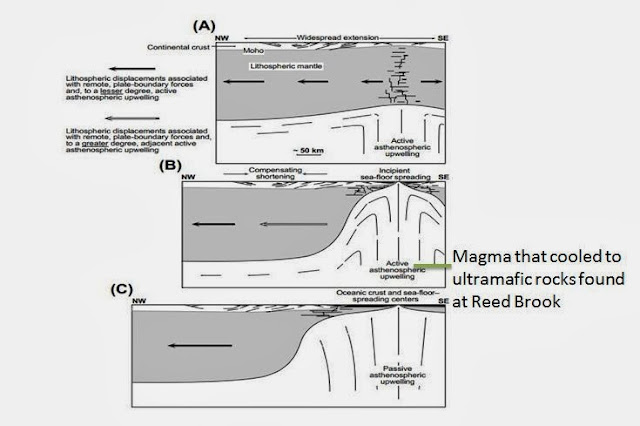
These are ultramafic rocks within the Rowe Formation. They were once thought to be ophiolite packages. ophiolite packages occur at suture zones after an orogeny. They are pieces of the earth's mantle that are uplifted into continental crust after a collision event. However, if the Rowe is not, in fact, a deep sea formation, then the ultramafics seen here are unlikely to be ophiolites. Instead, they could be a result of upwelling of the asthenosphere that occurred when the rifting phase transitioned to the drift phase. This view is presented by Withjack et al. in their 1998 paper. As the Moretown was thrust over the Rowe, the ultramafics may have been brought from the crust to the surface.

Stop 6: Moretown Formation
Mid-Ordovician

From the geologist's notebook- field notes
-Light and dark layers, alternating
-Gneissic fabric
-Light layers are a quartz-rich
-Also layers of a quartz-rich phyllitic schist, fine-grained
-Folded quartz veins (Figure 3.9)
-Light layers contain visible bedding
-Darker layers are biotite-rich
-Pyrite and calcopyrite within a "hodge podge" of rock types (Figure 3.8)


Figure 3.8: Pyrite inclusion within Moretown Formation seen at Stop 6


3.9: Moretown Formation, Stop 6. A large quartz vein is outlined in purple. The hand in the picture is completely covering the pyrite inclusion, providing a scale for the size of this inclusion.


Interpretation:
The Moretown Formation was likely part of the Shelburne Falls Arc Complex. The volcanic arc formed on a microcontinent, Moretown, which was once a part of Gondwana but rifted off. The zircons present in the Moretown show an affinity to Gondwana, supporting this claim. Moretown was thrust over the Rowe Schist when it collided with Laurentia during the Taconic Orogeny. Moretown will be discussed in more detail in the next post.

This map shows the locations of these sites on a Google map!

Conclusions
When we left off of our discussion of rift sediments, we had covered shelf deposits and slope/rise deposits. The next logical  progression seems to be rocks formed in even deeper water- the abyssal plane of the ocean. However, this field trip showed us that sediments like the Rowe Schist are not explained quite so simply.

In the past, the Hoosac and Rowe Schists were thought to be slope/rise sediments, with the "black, cruddy" Rowe Schist marking a transition to deeper ocean deposition in the form of an accretionary wedge of the Shelburne Falls Arc (discussed in more detail next week). However, there are alternative explanations for the formation of the Rowe that do not require its formation in the deep ocean and are actually more consistent with our observations, such as zircons that show an affinity for Laurentia. It is likely that the Rowe was actually formed solely on the slope/rise (and not in the deep ocean). The high carbon content of the black, cruddy Rowe, which is often interpreted as a product of anoxia in the deep ocean, could also be interpreted as a product of a sudden increase in sedimentation rates along the slope/rise, presenting oxygen from reaching buried sediments. Graphite is often formed in anoxic environments, but it is also possible that it percolated through faults, or zones of weakness, within the Rowe.

One possible explanation for the formation of the ultramafics from Reed Brook is that they are a product of extension, which caused magma from the mantle to upwell. The diagram below shows how upwelling of the asthenosphere can bring mantle material to the surface.

3.10: Diagram adapted from Withjack et al. (1998) shows how upwelling of the asthenosphere could occurr due to extensional rifting.

 The Moretown Formation will be analyzed in more detail next week. However, in order to have a basic understanding of how it fits in to the picture, it is important to note that the Moretown was previously interpreted as a fore-arc basin of the Shelburne Falls Volcanic Arc Complex. However, this is likely not the case... an argument that will be presented in regard to next week's field trip: Week 4: The Shelburne Falls Arc Complex.


Withjack, M.O., Schlische, R.W., and Olsen, P.E., 1998, Diachronous rifting, drifting, and inversion on the passive margin of central eastern North America: An analog for other passive margins: AAPG Bulletin
Personal communications with Paul Karabinos and Eloise Andry


Week 4: Shelburne Falls Arc Complex


Field Trip Four
Shelburne Falls, MA
October 3, 2013


In Field Trip 4, we saw formations that are predominantly related to the Shelburne Falls Arc Complex. The Shelburne Falls Arc was formed after subduction began on the East side of the Proto-Atlantic, closing the ocean. It was this active margin that allowed for the formation of the Shelburne Falls Arc Complex, a volcanic arc on Moretown, a microcontinent rifted from Gondwana. During the Taconic Orogeny, the Shelburne Falls Arc collided with Laurentia.


Cambrian-Ordovician:
Opening of Proto-Atlantic (Iapetus Ocean)
475 Ma: Formation of the Shelburne Falls Arc
Rifting of Gondwana

Ordovician:
460 Ma: Taconic Orogeny

4.i: Lithotectonic map showing the general location of the Week 4 field trip in Shelburne Falls, MA
4.ii: Zoomed in lithotectonic map showing the stops within the Peri-Laurentian Arc System


Stop 1: Moretown Formation
Mid-Ordovician

Description from USGS MA geological map:
-Green-gray or buff in color
-Fine-grained, pinstriped granofels (granoblastic, weak foliation) and schist

From the geologist's notebook- field notes
-3 layers within outcrop: schist, mafic, and epidote-rich
-Visible bedding, sedimentary protolith
-The schist layer is light-colored
-Schist layer has a pinstripe pattern that is also folded, deformed
-Schist contains quartz and feldspar
-The mafic layer appears to be a dike
-Dike is nearly horizontal, appears squished
-There is an alignment of grains within the mafic layers, shows flow structure
-Epidote-rich layer likely caused by hydrothermal alteration
-Multiple large, boudinaged folds
-Garnet and actinolite needles

-Strike: 45
-Dip: 49
-Trend: 100
-Plunge: 42

What is hydrothermal alteration?

Hydrothermal metamorphism occurs when extremely hot water that is rich in ions flows through rock fractures. This causes chemical alterations and is often associated with igneous/volcanic activity, since that generates enough heat and pressure to circulate the ion-rich fluids.


Figure 4.1: Mafic rock from Moretown Fm, Stop 1. Note the dark color and the fact that the grains are weakly aligned. 
Figure 4.2: Moretown Fm, Stop 1.  Visible mafic, biotite-rich layers interbedded with lighter-colored sedimentary layers, separated here by a  blue line.


Interpretation:
The Moretown, as previously stated, was a microcontinent of Gondwana that rifted off of the supercontinent. Originally, Moretown was thought to be associated with the Shelburne Falls Arc Complex, specifically a fore-arc wedge of the Shelburne Falls Volcanic Arc. However, the zircons of Moretown date back farther than the formation of the Shelburne Falls Arc; Moretown is too old to be formed as part of the arc complex. The zircons show affinities for Gondwana, which is why it is now suspected that Moretown rifted off of Gondwana and that the volcanic arc formed on top of it. The ultramafic rocks found in the Moretown Formation were probably dikes that intruded later in the Moretown's history.


Stop 2: Hallockville Pond Gneiss
Ordovician

Description from MA USGS geologic map:
-Light gray in color, foliated
-Microcline-plagioclase-quartz biotite gneiss
-Microcline found in large crystals (megacrysts)


From the geologist's notebook- field notes
-Granite diorite (felsic, plutonic gneiss)
-Alternates between very light and very dark layers
-Dark layers are biotite-rich, shiny
-Captures two different deformations: one caused the layering, the second folded the layers
-Appelite dikes present in gneiss
-Some dikes, apear to be folded

Figure 4.3: Hallockville Pond Gneiss (granite diorite) from Stop 2. The annotated orange lines to the left of number 1 show the first stage of deformation, the pinstripe pattern. The line annotated to the right of number 2 shows the second deformation, folding of the pinstripes. 


Interpretation:
An east-dipping subduction zone underneath Moretown occurred before the formation of the volcanic arc. It was this subduction zone that produced the Hallockville Pond Gneiss, a pluton that intruded Moretown as granodiorite. There are two evident stages of deformation seen in this outcrop: the first caused layering, the second folded the layers. These two deformations likely occurred first when Shelburne Falls collided with Laurentia (the Taconic Orogeny), and second during the Acadian Orogeny, when Avalonia collided with Laurentia.


Stop 3: Hawley Volcanics
Mid-Ordovician

Description from MA USGS geologic map:
-Interbedded amphibolite, greenstone, feldspathic schist, and granofels
-Underlies the Goshen Formation
-Coarse hornblende occurs in certain locations, coarse plagioclase in some amphibolites near the top of the formation


From the geologist's notebook- field notes
-Mafic rocks
-Black in color
-Contains hornblende, actinolite, plagioclase, quartz feldspar
-Actinolite caused by lower-grade metamorphism than previous sites
-"Green pods" of epidote, caused by either percolating sea water, a MOR, or is a product of metamorphosis
-Basalt is likely pillowed, hard to tell for sure
-Pillows are deformed, not perfect circles
-Visible vesicles in basalt

What is an MOR?
"MOR" stands for mid-ocean ridge, which is an oceanic ridge within underwater mountain chains that serves as spreading centers. "Spreading centers" are locations of underwater rifting where the upwelling of magma occurs, cooling into new oceanic crust that spreads outward from the spreading center.


4.4: Hawley Volcanics, Mid-Ordovician, from stop 3. Outlined in orange is what could be interpreted as a single "pillow," caused by rapid cooling of magma when ejected into water.

Figure 4.5, Hawley Volcanics, Mid-Ordovician, close-up of single pillow. Note the vesicles, highlighted with an orange box, a common feature of mafic rocks that cooled quickly. Also note the deformed circularity of the pillow, indicating deformation of this meta-basalt. 

Interpretation:
The Hawley Volcanics were deposited by underwater volcanoes. We know this because they are mafic rocks, and the pillowed texture indicates that they cooled very rapidly underwater. They were a result of eruptions of the Shelburne Falls Volcanic Arc, probably when the volcanic arc and the underlying Moretown were close to Laurentia, since the zircons from Hawley have Laurentian signatures.


Stop 4: Collinsville Formation, Core of Shelburne Falls Dome
Mid-Ordovician

Description from the MA USGS map:
-Garnetiferous biotite gneiss
-Contains "clots" of chlorite
-Depletion halos
-Homogenous

From the geologist's notebook- field notes
-Contains dark (mafic) plutonic rocks and light (felsic) plutonic rocks
-Felsic layers are tonalite, somewhat granitic-looking (tonalite is sodium and calcium-rich granite with no potassium feldspar)
-Tonalite is strongly foliated
-The mafic layers are interbedded and also appear to be dikes that chilled as they intruded the cool tonalite
-Potholes evident, caused by steam erosion
-Lots of veins cutting through the tonalite, many cross-cutting each other
-Some pegmatites are still straight, show obvious cross-cutting
-Numerous quartz veins present

-Strike: 100, Dip: 10
-East/West lineations

Figure 4.6: View of the Deerfield River at Stop 4

Figure 4.7: Cross-cutting pegmatites (the white lines) within the tonalite(black rock) of the Collinsville formation, stop 4


Interpretation: 
The Collinsville Formation is the core of the Shelburne Falls Volcanic Arc Complex. The rocks have differentiated layers of mafic and felsic rocks and strong foliations. The mafic layers intruder the cool tonalite and cooled. This gneissic fabric was caused by deformation, likely during the Acadian Orogeny. Many of the pegmatites cross-cut the mafic and felsic foliated layers, telling us that they intruded the Collinsville Formation at a layer time than the original formation of the tonalite (Figure 4.9). The final phase of deformation caused doming.


To see these sites on a Google map, please look here!

Conclusions
In this section, I will go into more detail about the chronology of the events involving the Shelburne Falls Arc Complex.

The Shelburne Falls Volcanic Arc was built on the Moretown Formation, previously interpreted as a fore-arc basin of the volcanic arc. However, when Moretown was dated, it was discovered that the zircons pre-date the formation of the volcanic arc and actually show affinities with Gondwana (Africa). It is now interpreted as a microcontinent that rifted away from Gondwana. 

During the Taconic Orogeny of the Ordovician (460 Ma), the Shelburne Falls Arc on the Moretown collided with Laurentia. The Hallockville Pond Gneiss intruded the Moretown as a pluton that was produced during subduction, which began after the collision transformed Laurentia back into an active margin.

When the volcanos that formed the volcanic arc exploded, they erupted mafic magma into water, causing it to cool quickly into pillow basalts on top of the Moretown, which was sitting at a depth that allowed it to be covered in water. These formed the Hawley Volcanics. There may also be feeder dikes that traverse from the Hawley to the Moretown and allowed for this deposition, but we have no evidence of feeder dikes. If no feeder dikes were present, it is likely that the Moretown was originally to the East of Hawley but that it was thrust over to the West during the collision. We know this because the Hawley contains zircons with Laurentian affinities, implying that it was, at one time, likely adjacent to Laurentia. 

Finally,  the Collinsville Formation represents the core of the Shelburne Falls Arc Complex. 

In the past, it was thought that the Bronson Hill Volcanic Arc Complex collided with Laurentia during the Taconic Orogeny. We now know, from the work done by Karabinos et al. in 1998, that the Bronson Hill Arc was formed after the Taconic Orogeny as a result of the collision and the ensuing active margin. It was the Shelburne Falls Volcanic Arc that collided during the Taconic Orogeny, however. Karabinos et al. used the following information to conclude this:

"(1) No definitive evidence exists that rocks in the Bronson Hill arc underwent Taconian deformation or metamorphism.
(2) 40Ar/39Ar cooling ages from Laurentian margin rocks related to Taconian metamorphism in southern Quebec, Vermont, and western Massachusetts range in age from 470 to 460 Ma (Laird et al., 1984; Sutter et al.,1985; Hames and Hodges, 1993; Castonguay et al., 1997) and are 15 to 30 m.y. older than arc related rocks dated by Tucker and Robinson (1990) in the Bronson Hill arc.
(3) The age of emplacement of the Giddings Brook thrust sheet in the Taconic Range in Vermont is constrained by the presence of Orthograptus truncatus in flysch below the thrust (Zen, 1967) to have taken place during late Trenton time. Thus, thrusting in the western part of the Taconian thrust belt occurred ca. 460 to 455 Ma.
 (4) The Middlefield Granite in Middlefield, Massachusetts, intruded the Moretown Formation and the Rowe Schist at their contact, which was interpreted as a Taconian thrust by Stanley and Hatch (1988), but the pluton is not offset at the contact. Therefore, the 447 ±3 Ma zircon evaporation age of the Middlefield Granite (Karabinos and Williamson, 1994) indicates that Taconian thrusting in the eastern part of the thrust belt ended before or possibly during formation of the Bronson Hill arc" (Karabinos et al. 1998)

4.8: Figure adapted from Karabinos et al, 1998. Included are the likely locations of the formations from the field trip before any thrusting occurred. The lower image shows the reversal in subduction polarity that occurred after the collision of the Shelburne Falls Arc turned the Laurentian margin from a passive margin to an active one with a west-dipping subduction zone. This subduction allowed for the intrusion of the Hallockville Pond Gneiss.  


Karabinos, P.M., Samson, S., Hepburn, J.C.,Stoll, H., 1998, Taconian Orogeny in the New England Appalachians: Collision between Laurentia and the Shelburne Falls Arc